Those of you who have been following this blog a while will remember that I took part in two of the Transport for London (tfl) Safer Cycling Innovations trials earlier in the year at the Transport research laboratory (TRL). I went back again last week and this time, I have some of my own photos!
This time, it was a day hosted by the Chartered Institute of Logistics & Transport (CILT), but delegates included a wide range of people from many organisations. Incidentally, CILT has created The Hub, a cycling resource which has a fair bit of information from the former Cycling England which was shoved on the bonfire of the quangos by the greenest government ever.
The day was split into two parts. First, there was a tour around some of trial sites within TRL with a chance to ask the project staff questions about the trials themselves. The second part of the day saw a various presentations about cycling schemes around the UK and indeed the world.
 On the trials, the first thing I saw was the TRL car simulator. Essentially a car in a room, surrounded by projectors, but Grand Theft Auto it was not. The car sat on little jacks which could give a feeling of acceleration and movement and even after a few minutes, the oncoming vehicles were uncanny.
The trial allowed different road layouts to be tested in a perfectly safe environment and included ideas for continuing cycle lanes across side road to reduce the risk of left hook. An interesting fact was that TFL calibrates the set up from time to time by taking a car out on the track to compare the handling and so keeping the model accurate. The car had cameras watching the driver and so could track eye movements and so interesting data could be had.
 Then, we moved onto the cycle simulator which was on a series of 5 large TV screens. The main three gave a wide field of view. One on its side gave the view down onto the road and one was set out to allow the tester to see what was happening over their right shoulder. The bike was a London Cycle Hire model, but the simulator could be set up with different machines. Indeed, the set up was luggable with a van and so could be set up anywhere.
The view was uncanny again, but the set up couldn't really create the feedback to the cyclists in terms of uneven roads, leaning and so on. The virtual drivers were gifted with advanced artificial intelligence and "knew" the bike was there, even to the extend bad driving could be thrown in. One thing TRL are looking at is whether cyclists can signal and so change the behaviour of the AI.
Outside, we were led to the now quite famous Dutch Roundabout. Essentially, it is based on a "continental" or "compact" roundabout which is arranged with tight turns for traffic, a one lane in/ one lane out set up, a single lane width circulatory area and an overrun for larger vehicles. The idea is to keep traffic speeds down so people move through the roundabout smoothly and safely.
The "Dutch" element was to put a cycle track all the way round the edge of the roundabout, set back around 5 metres from the edge of the traffic circulatory area. Various entry and exit arrangement were provided with a varying type of protection from traffic and the track is set up so right turning cyclists go three-quarters of the way round the roundabout. For pedestrians, crossing points are provide outside the cycle track circle. Various road markings and zebra crossing arrangements were in place (and some uncontrolled crossings for pedestrians).
Some of the layouts were (in my view) almost UK legal and some were a little more "non-standard", including "dragon's teeth" give way markings and "elephant's feet" marking the cycle track where crossing the carriageway. Things were set up to give cyclists priority over traffic.
The one thing which does stick out (of the ground!) is the absolute forest of Belisha beacons at the zebra crossing points. In the UK, zebra crossings have to have zig-zags, stripes and Belisha beacons, whereas in other countries, the stripes alone are enough. In my view, I cannot see a major need for Belisha beacons where stripes are used over a cycle track to give pedestrian priority, although I would be interested to know the views of visual impairment representatives. Perhaps a black and white zebra bollard is the answer, perhaps with a tactile symbol on top to help those with reduced vision?
There was a debate on the relatively short distance between the cycle track and the traffic give way point at the roundabout. One thought was that drivers are larger cars and vans would end up stopping at the roundabout with their back end blocking the track. Conversely, the other thought was that in seeing what was going on, drivers of larger vehicles might stop at the zebra to allow cyclists or pedestrians to pass before moving the the roundabout give way. I guess that is what the trial will be showing us! As for when such a layout will be tried "live" on the streets of London, well my money is on the Lambeth Bridge northern roundabout.


 Next up, the protected cycle track trial. TRL had set up various 100 metre sections of cycle track using different forms of protection to gauge the views of people cycling, driving and riding motorbikes. They tested a kerb, a line of traffic cylinders (which you can just see in the photo, thy are just bolted in and are flexible if hit) and a line of Zicla Zebras (which people are calling Armadillos in the UK - I guess to stop confusion with zebra crossings!). TRL used detectors in the track surface to gauge speed and riding position which will give some interesting data.
The Ziclas have already been deployed in Royal College Street in what is now known as a "light segregation" scheme, that is, people riding bikes can go in and out of the cycle lane, but are protected from traffic.
Not surprisingly, people cycling felt safer with the kerb, but the other two methods also made people feel safer. Drivers, apparently, were quite happy with the separation, but motorbike riders were unhappy at having lost the "escape lane" created by a paint only cycle lane.
I am a fan of the Ziclas (subject to pedestrians not tripping over them) and how they have been used in Royal College Street, but only time will tell if the idea is rolled out more widely, although layouts using them are likely to by in the forthcoming and reworked TfL London Cycling Design Standards. What we can be doing now is using the cylinders to create almost instant protection for people on bikes which would allow a rapid roll out of facilities rather than waiting to spend a fortune on kerbing as layouts might need tweaking. Money could then be spent getting junctions sorted out.
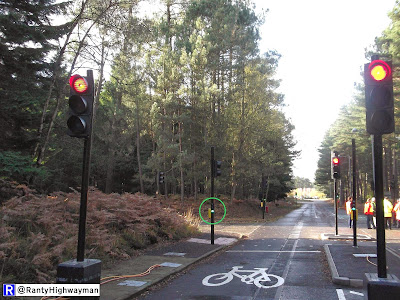
We then went for a look at the "floating" bus stop/ bus stop bypass/ bus stop island arrangement which was one the trials I took part in earlier in the year. Essentially, the layout provides a cycle track behind the passenger waiting area (which is on an "island") so that people on bikes don't need to overtake buses. Passengers need to cross the cycle track and TRL trialled uncontrolled crossings, a zebra crossing (more Belisha beacons!) and a humped zebra crossing. Speaking to others, it is seems that the trial layout is better than the one recently installed on the London Cycle Superhighway 2 extension at Stratford. Oh dear!
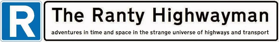
 The final trial of the day was a look at cycle signals, which was the other trial I took part in. The first layout was a puffin crossing which had the usual traffic signals for drivers, but these were replicated by little signals with cycle logos and showed at the same time as the main traffic signals. At the moment, full-sized signals are the only permitted type for cycles and the red cycle stop is not allowed.
 To do anything remotely useful at the moment, we end up with lots of poles and signals and potential for confusion where drivers and bike riders look at each other's signals by mistake. The little signals placed at a low level cannot be mistaken. TRL have had to test the red cycle stop on full size signals before then trying the cycle signals. All part of the "fun" needed to get Department for Transport Approval which may well be next year according to those with ears to the ground!
 We then wandered up to a four arm signalised junction with one arm being a one-way street. As with the roundabout, each arm was a little different and TRL had been testing various sub-arrangements. We got to see an example of "early start" which has usual traffic signals at the vehicle stop line and a little cycle signal at the cycle stop line of an advanced stop line (ASL).
The idea is to give bike riders a green cycle signal a few seconds before traffic. This will allow cycles to pretty much clear the junction before traffic is released and would stop the left hook problem at traffic signals. The problem with early start, though, is that it offers no protection to bike riders when the main signals are green. That issue aside, getting the little cycle signals approved by DfT will open a huge range of possibilities - that is for another post perhaps!
The afternoon was in the warm lecture room and I won't go into detail here, but I would say that TfL's Brian Deegan gave an interesting insight into the Royal College Street scheme and Phil Jones (of Phil Jones Associates) gave a galloping piece on a world-wide study tour of cycling infrastructure (a report coming out soon hopefully).
What I found especially interesting, though, was the presentation given by Brighton & Hove Council on the Lewes Road Transport Improvements which has taken a dual carriageway and remodelled to give a 2 metre cycle lane, 3 metre bus lane and a 3 metre traffic lane. The bus stops are floating and since opening, there has been a significant shift from private car to bike. I am looking forward to the report planned for the scheme. There was also the Old Shoreham Road scheme which essentially stuck a Copenhagen style cycle track on each side of an old main road.
I do get to have some interesting days out of the office and this one has left all sorts of ideas rolling around in my head!

The trial allowed different road layouts to be tested in a perfectly safe environment and included ideas for continuing cycle lanes across side road to reduce the risk of left hook. An interesting fact was that TFL calibrates the set up from time to time by taking a car out on the track to compare the handling and so keeping the model accurate. The car had cameras watching the driver and so could track eye movements and so interesting data could be had.

The view was uncanny again, but the set up couldn't really create the feedback to the cyclists in terms of uneven roads, leaning and so on. The virtual drivers were gifted with advanced artificial intelligence and "knew" the bike was there, even to the extend bad driving could be thrown in. One thing TRL are looking at is whether cyclists can signal and so change the behaviour of the AI.
 |
| Sort of Dutchish. Image from Google Maps. |
The "Dutch" element was to put a cycle track all the way round the edge of the roundabout, set back around 5 metres from the edge of the traffic circulatory area. Various entry and exit arrangement were provided with a varying type of protection from traffic and the track is set up so right turning cyclists go three-quarters of the way round the roundabout. For pedestrians, crossing points are provide outside the cycle track circle. Various road markings and zebra crossing arrangements were in place (and some uncontrolled crossings for pedestrians).
 |
| This arm has dragon's teeth which are little triangles indicating that drivers much give way to cycles as well as the usual zebra stripes. Leaving the roundabout, the same markings are present and mean give way as well. The neatest arrangement, but not UK legal. |
The one thing which does stick out (of the ground!) is the absolute forest of Belisha beacons at the zebra crossing points. In the UK, zebra crossings have to have zig-zags, stripes and Belisha beacons, whereas in other countries, the stripes alone are enough. In my view, I cannot see a major need for Belisha beacons where stripes are used over a cycle track to give pedestrian priority, although I would be interested to know the views of visual impairment representatives. Perhaps a black and white zebra bollard is the answer, perhaps with a tactile symbol on top to help those with reduced vision?
 |
| Leaving the circulatory area, drivers need to give way to cycles at the dragon's teeth. |


 |
| I think this arm is almost UK legal. Drivers leaving the roundabout have to give way to cyclists and then the zebra crossing as normal beyond. The one thing not right for the UK is that the cycle track is meant to be on a speed hump which is daft. Of course, the profusion of road markings is very messy and needs to be tidied up. |

The Ziclas have already been deployed in Royal College Street in what is now known as a "light segregation" scheme, that is, people riding bikes can go in and out of the cycle lane, but are protected from traffic.
Not surprisingly, people cycling felt safer with the kerb, but the other two methods also made people feel safer. Drivers, apparently, were quite happy with the separation, but motorbike riders were unhappy at having lost the "escape lane" created by a paint only cycle lane.
 |
| Gentle entry angle into bypass. |
 |
| The passenger islands was a bit narrow for my liking, but it does allow to test for crowding and he impact on cycling past. |
 |
| A small hump at the zebra crossing to encourage those on bikes to slow down and let people cross. |
 |
| The zebra crossing. I am pedantic, but the Belisha beacon post and tactile paving on the far side should mirror the layout on the near side as the track is one-way. I am so sad! |
 |
| At the end of the bypass, the bus stop island gives protection from following traffic and has a gentle taper again. |


The idea is to give bike riders a green cycle signal a few seconds before traffic. This will allow cycles to pretty much clear the junction before traffic is released and would stop the left hook problem at traffic signals. The problem with early start, though, is that it offers no protection to bike riders when the main signals are green. That issue aside, getting the little cycle signals approved by DfT will open a huge range of possibilities - that is for another post perhaps!
The afternoon was in the warm lecture room and I won't go into detail here, but I would say that TfL's Brian Deegan gave an interesting insight into the Royal College Street scheme and Phil Jones (of Phil Jones Associates) gave a galloping piece on a world-wide study tour of cycling infrastructure (a report coming out soon hopefully).
What I found especially interesting, though, was the presentation given by Brighton & Hove Council on the Lewes Road Transport Improvements which has taken a dual carriageway and remodelled to give a 2 metre cycle lane, 3 metre bus lane and a 3 metre traffic lane. The bus stops are floating and since opening, there has been a significant shift from private car to bike. I am looking forward to the report planned for the scheme. There was also the Old Shoreham Road scheme which essentially stuck a Copenhagen style cycle track on each side of an old main road.
I do get to have some interesting days out of the office and this one has left all sorts of ideas rolling around in my head!


.JPG)


